• Skip to primary navigation
  • Skip to main content
Southern Rockies Fire Science Network

Southern Rockies Fire Science Network

JFSP Fire Science Exchange Network

  • Home
  • About
    • About Us
    • Our Partners
  • Subregions
    • Why Subregions?
    • Black Hills
    • Wyoming Sagebrush
    • Uinta Basin
    • Wasatch Plateaus/Mountains
    • Rocky Mountains
    • Canyonlands/Desert Montane
  • Events
    • Event Summaries
  • Resources
    • Pre and Post-Fire Emergency Resources
    • Research & Publications
    • Maps, Models & Apps
    • COVID-19
  • Contact
  • Show Search
Hide Search

Protecting the source: Tools to evaluate fuel treatment cost vs. water quality protection

From the Rocky Mountain Research Station:

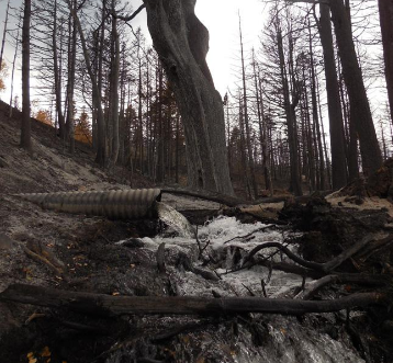
High-intensity wildfires are one of the leading causes of severe soil erosion in western U.S. watersheds. This erosion can lead to disruptive deposits of sediment in reservoirs and water supply systems. For this reason, land managers can benefit from estimating the erosion potential of high-intensity wildfires in order to decide where to focus fuel reduction efforts.

Read the brief here.

Read the original research here.

Posted by:
Gloria Edwards
Published on:
April 8, 2020

Categories: Maps, Models, and Apps, Publication, Research Brief/SynthesisTags: fire behavior modeling, fire effects modeling, fire-adapted communities and fire response, Forest Management, forests, high-severity wildfire, landscape restoration and resilience, Model/Tool/Technology, post-fire debris flows, post-fire erosion, post-fire runoff, pre-fire risk assessment, Rocky Mountain Research Station, stream sedimentation, watershed impacts, watershed management, watersheds

Footer

Connect With Us

  • Facebook
  • Twitter
  • YouTube

Sign up for our newsletter

Got a Question?
Email us.

This regional Fire Exchange is one of 15 regional fire science exchanges sponsored by the Joint Fire Science Program (JFSP).
View resources from multiple exchanges.