
-
Reducing fuels on steep slopes

How partnerships and technology advancements are moving critical forest restoration work forward Read HERE
-
New Tools for Modern Land Management Decisions – New tools for the Upper CO River Basin

“In an era of rapid land use changes, it is imperative that land managers and policymakers have actionable and current information available for decision processes. In this work, we seek
-
Invasive grass influences on the fire-cycle and treatment effectiveness to control their abundance in the Intermountain West, USA
“We performed a review and meta-analysis of recent (1985 – 2023) scientific literature. We focused on the Intermountain West, USA, where six dominant invasive grass species have already transformed ecosystems,
-
Loss of Ecosystem Resistance to Invasion after Wildfire Facilitated by a Pulse of Soil Nitrogen Availability: Experimental Evidence in the Burned Sagebrush Steppe: Loss of Resistance Explained by Soil N PulseT. M. Maxwell and others
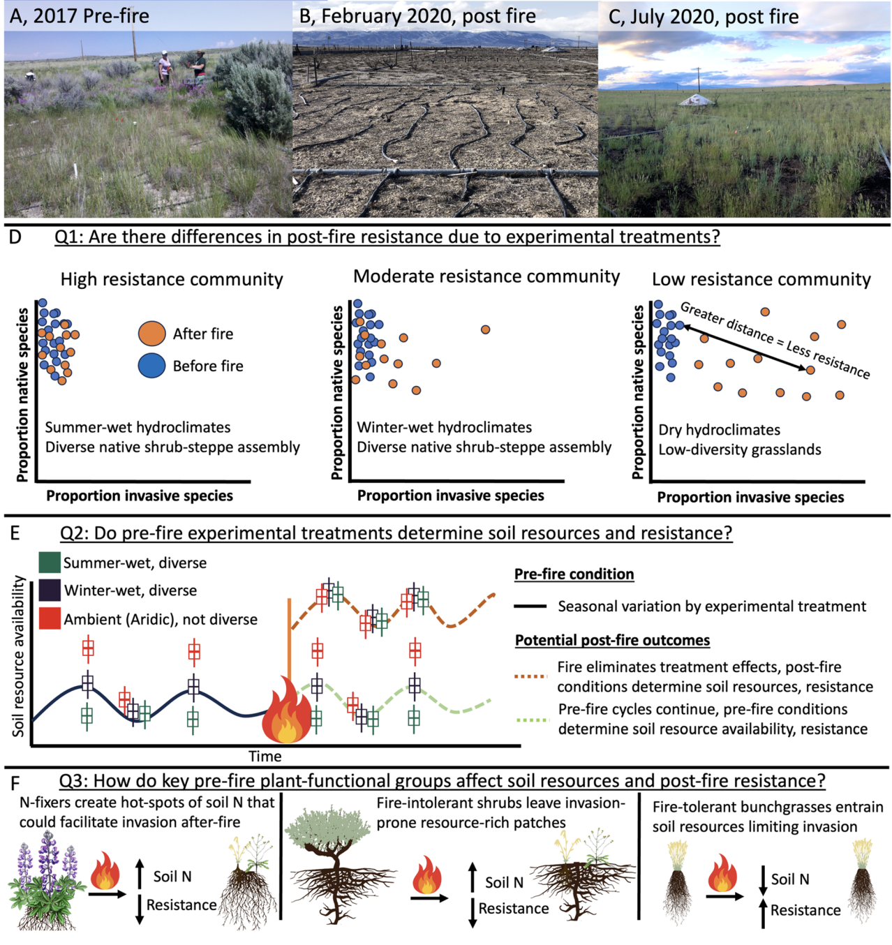
“We asked whether patterns of invasion after the compound disturbance of drought and fire related to the long-term pre-fire climate and plant community structure”. Read HERE
-
Science You Can Use Tool: Raster Tools: Leveraging spatial analysis and AI towards a fire-resilient future, in minutes
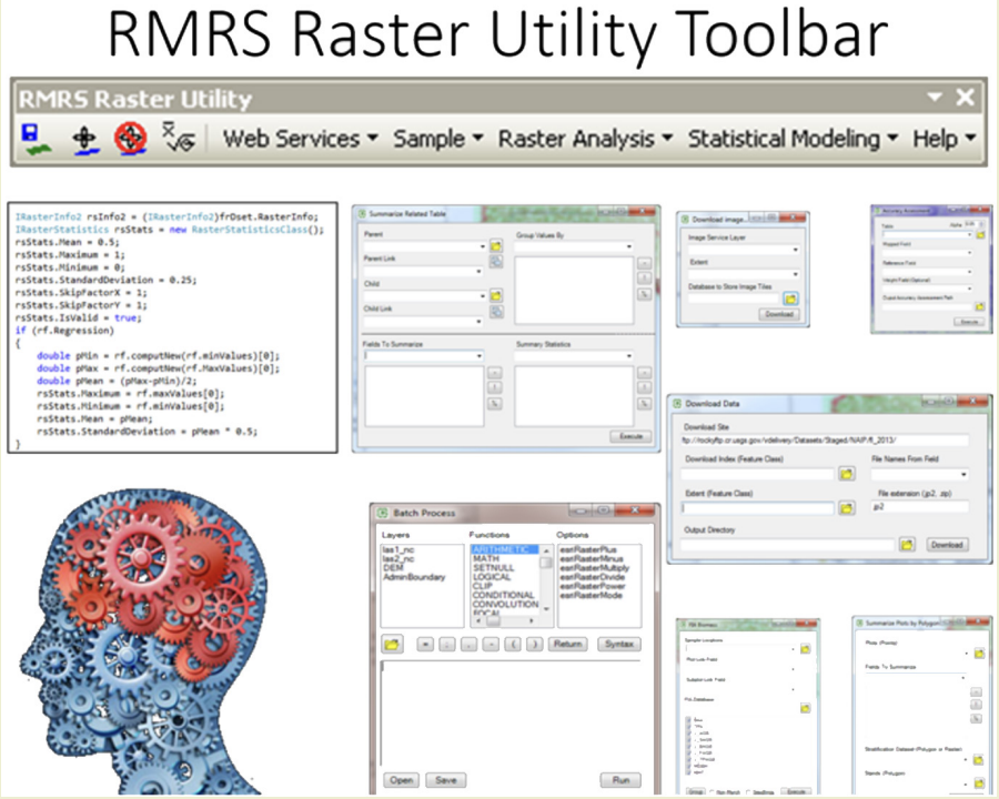
“To effectively manage fire, land and fire managers need detailed, current local information – for example, the amount of burnable material present, fuel moisture levels, winds, temperatures, and terrain changes
-
Fuel treatments are supposed to protect forests from wildfire. How do we know if they’re working?
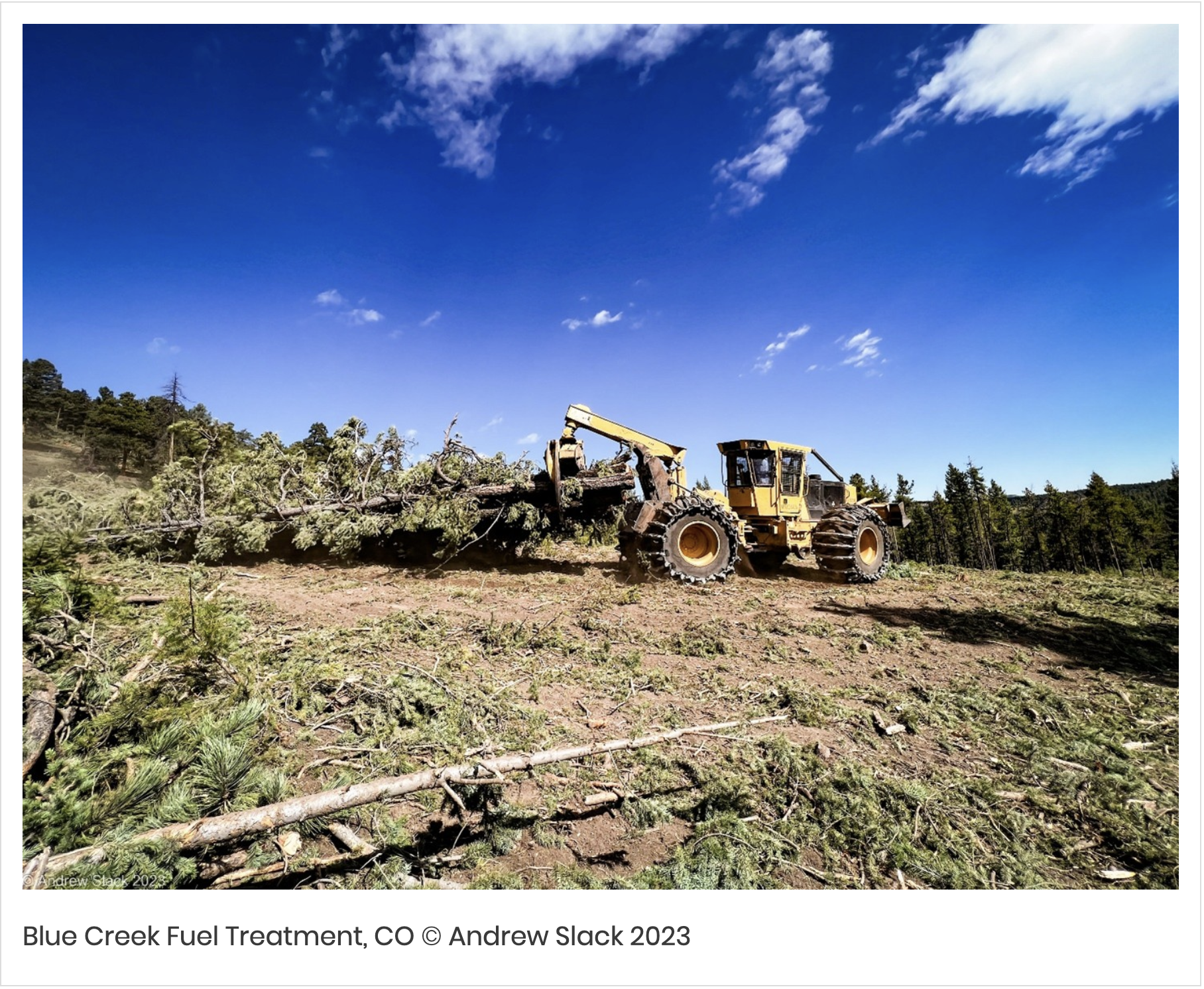
Guest post by Anson Call, 2025-2026 Sustainability Leadership Fellow and Postdoctoral Fellow in the Department of Forest and Rangeland Stewardship and Colorado Forest Restoration Institute Read HERE
-
USU study: more days over 80 degrees means more fire
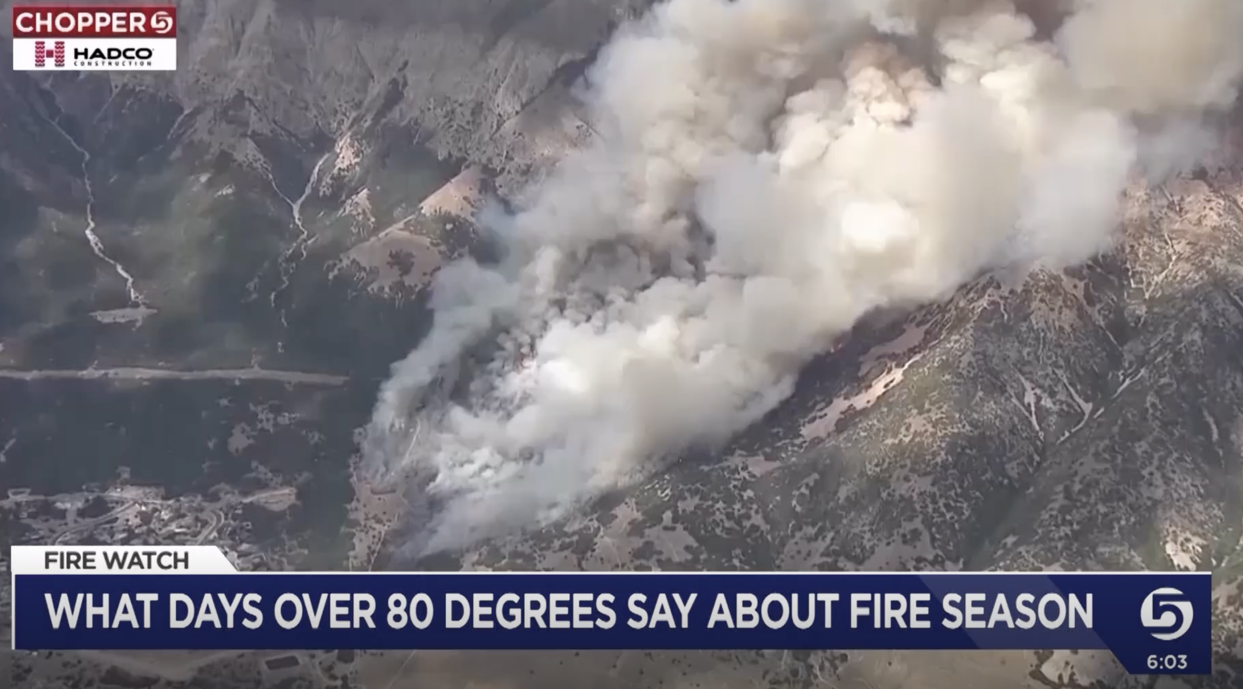
“LOGAN — Researchers at Utah State University said the number of days we see over 80 degrees can serve as a strong indicator of how our fire season will be.”
-
National Significant Wildland Potential Outlook: Predictive Services National Interagency Fire center
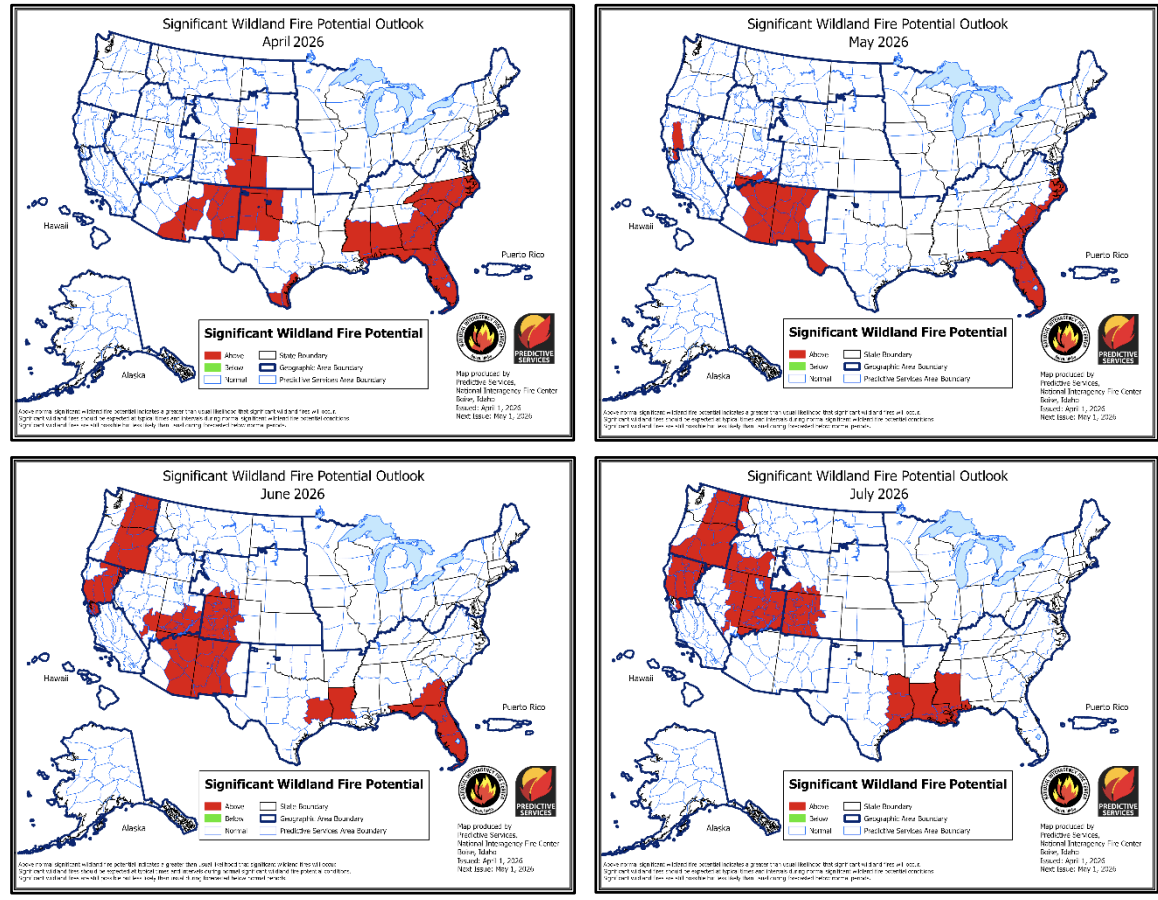
“The significant wildland fire potential forecasts included in this outlook represent the cumulative forecasts of the ten Geographic Area Predictive Services units and the National Predictive Services unit.” Read HERE
-
Society for the Protection of Underground Networks: Underground Atlas

Explore the distribution of arbuscular mycorrhizal (AM) and ectomycorrhizal (EcM) fungi to identify biodiversity hotspots and areas with rare, endemic fungi. Tap or click anywhere on the map to see
-
Mature and Old-Growth Forests: Analysis of Threats on LandsManaged by the Forest Service andBureau of Land Management
“This report was prepared in response to Executive Order (E.O.) 14072, which instructed the U.S. Department of Agriculture (USDA), Forest Service and U.S. Department of the Interior, Bureau of Land
Categories
- Article/Book/Chapter
- Course/Curriculum
- Education & Training
- Highlights
- Maps, Models, and Apps
- Newsletter/Digest
- Pre and Post Emergency Resources
- Publication
- Research Brief/Synthesis
- Technical Report
- Uncategorized
- Video
- Video & Audio Resources
- Webinar
- Website
Archive
- April 2026
- March 2026
- February 2026
- January 2026
- December 2025
- November 2025
- October 2025
- September 2025
- August 2025
- July 2025
- May 2025
- April 2025
- March 2025
- February 2025
- January 2025
- November 2023
- October 2023
- September 2023
- May 2023
- April 2022
- March 2022
- February 2022
- January 2022
- October 2021
- August 2021
- July 2021
- May 2021
- March 2021
- February 2021
- January 2021
- December 2020
- November 2020
- October 2020
- September 2020
- August 2020
- July 2020
- June 2020
- May 2020
- April 2020
- March 2020
- July 2019
- July 2018
- June 2018
- October 2017
- September 2017
- June 2017
- April 2017
- March 2017
- November 2016
- October 2016
- August 2016
- May 2016
- April 2016
- November 2015
- October 2015
- September 2015
- June 2015