
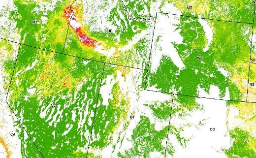
The dataset provides an estimate of 2017 herbaceous annual percent cover predicted on May 1st with an emphasis on annual grasses. The pixel values range from 0 to100 with an overall mean value of 7.1 and a standard deviation of +/-10.5. The model’s test mean error rate (n = 1670), based on nine different randomizations, equals 4.9% with a standard deviation of +/- 0.15. This dataset was generated by integrating ground-truth measurements of annual herbaceous percent cover with 250-m spatial resolution eMODIS NDVI satellite derived data and geophysical variables into regression-tree software. The geographic coverage includes the Great Basin, the Snake River Plain, the state of Wyoming, and contiguous areas. We applied a mask to areas above 2250-m elevation because annual grasses are unlikely to exist at substantial cover above this threshold. To target likely sagebrush ecosystems, the mask also hid pixels classified as something other than shrub or grassland/herbaceous by the 2011 National Land Cover Dataset (NLCD). Cheatgrass (Bromus tectorum) is the most common annual grass in the study area. It grows from seed, usually in spring, matures quickly, produces seed, and dies. After dying, cheatgrass contributes fine fuels that faciliate fire ignition and spread throughout sagebrush ecosystems. These fires remove sagebrush stands. Increasing fire return intervals, land management practices, and development have all contributed to the fragmentation of the once expansive sagebrush ecosystems. These ecosystems are critical for water quality, reduced fire threats, and the survival of sagebrush-dependent wildlife.
Image Source: ScienceBase-Catalog