• Skip to primary navigation
  • Skip to main content
Southern Rockies Fire Science Network

Southern Rockies Fire Science Network

JFSP Fire Science Exchange Network

  • Home
  • About
    • About Us
    • Our Partners
  • Subregions
    • Why Subregions?
    • Black Hills
    • Wyoming Sagebrush
    • Uinta Basin
    • Wasatch Plateaus/Mountains
    • Rocky Mountains
    • Canyonlands/Desert Montane
  • Events
    • Event Summaries
  • Resources
    • Pre and Post-Fire Emergency Resources
    • Research & Publications
    • Maps, Models & Apps
    • COVID-19
  • Contact
  • Show Search
Hide Search

New Operational National Satellite Burned Area Product

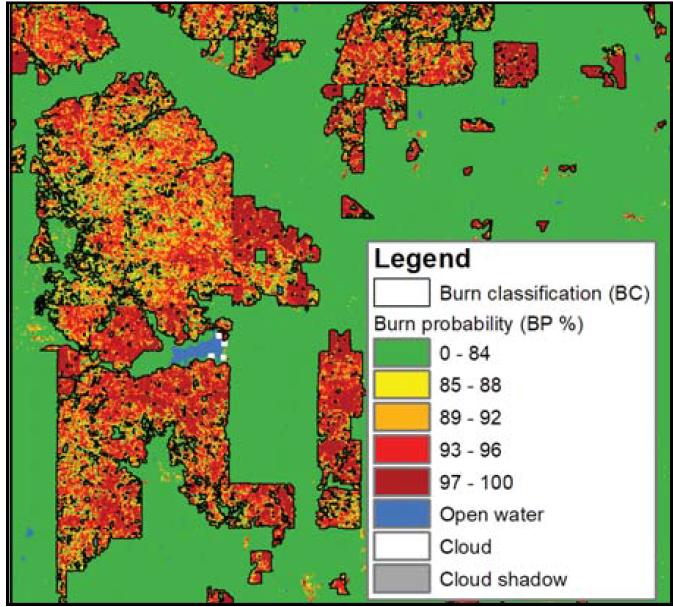
New 1-pager from USGS, Great Plains Fire Science Exchange, and SRFSN: New Operational National Satellite Burned Area Product. Land management and large-scale assessments of fire activity are hindered by the inconsistencies related to spatial and temporal fire information. There are a variety of uses remote-sensing can have in the wildland fire interface, these including monitoring of fire activity, augment existing fire data, and fill in information gaps.

T. Hawbaker, M. Vanderhoof, G. Schmidt, Y. Beal, J. Pico􀆩 e, J. Takacs, J. Falgout, and J. Dwyer. New Operational National Satellite Burned Area Product. 2020.

Youtube Video: SFE Webinar: Mapping burned areas from the Landsat archive

Hawbaker, T.J., Vanderhoof, M.K., Teske, C. and Noble, J. 2019. Mapping burned areas from the Landsat archive Southern Fire Exchange Webinar, April 24, 2019. https://www.youtube.com/watch?v=TuXhNl6zlDo

Monitoring Trends in Burn Severity:􀆩https://www.mtbs.gov/

Posted by:
Gloria Edwards
Published on:
September 5, 2020

Categories: Maps, Models, and Apps, Research Brief/SynthesisTags: aerial mapping, collaborative fire management, fire data, fire management, fire management history, fire managers, fire severity, fire technology, firefighting, forest mapping, GIS & Remote Sensing, high-severity wildfire, mapping, prescribed fire management, rangeland fire management strategy, satellite data, USFS, vegetation mapping, wildfire management, wildfire severity, Wildland Fire, Wildland Firefighting

Footer

Connect With Us

  • Facebook
  • Twitter
  • YouTube

Sign up for our newsletter

Got a Question?
Email us.

This regional Fire Exchange is one of 15 regional fire science exchanges sponsored by the Joint Fire Science Program (JFSP).
View resources from multiple exchanges.