
"This data publication includes uncrewed aerial system (UAS) imagery collected in 2023 to characterize the forest spatial pattern …
Smoothed raster of wildfire transmission to buildings in the continental United States and Hawaii (4th Edition)
"This data publication includes three geodatabase rasters that represent spatial assessments across the conterminous United …
Interactions of 2021 Schneider Springs burned area, containment lines, PODs, and suppression success
"In August of 2021 the Schnieder Springs fire ignited on the Okanogan-Wenatchee National Forest in Washington, where it burned …
A geostatistical approach to enhancing national forest biomass assessments with Earth Observation to aid climate policy needs
"In collaboration with the Comisión Nacional Forestal (CONAFOR), this study develops a geostatistical model that integrates …

2025 Colorado Forest Collaboratives Summit: Summary & Resources
"In early 2025, when organizations were facing change and uncertainty about policy and funding, the CFCN Advisory Council met to …
Continue Reading about 2025 Colorado Forest Collaboratives Summit: Summary & Resources
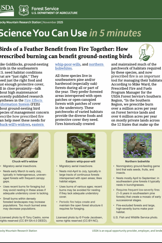
Birds of a Feather Benefit from Fire Together: How prescribed burning can benefit ground-nesting birds
Science You Can Use in 5 minutes Rocky Mountain Research Station | November 2025 Read HERE …

Estimating Wildfire Rate of Spread in Grasslands
Marty Alexander, PhD, RPFProprietor, Wild Rose Fire Behaviour, Leduc County, AB Read HERE …
Continue Reading about Estimating Wildfire Rate of Spread in Grasslands

Give seeds a chance? Opportunities and techniques for post‐fire reforestation using tree seeding
"Altered fire regimes and post-fire tree regeneration failures have the potential to drive forest cover losses throughout western …