• Skip to primary navigation
  • Skip to main content
Southern Rockies Fire Science Network

Southern Rockies Fire Science Network

JFSP Fire Science Exchange Network

  • Home
  • About
    • About Us
    • Our Partners
  • Subregions
    • Why Subregions?
    • Black Hills
    • Wyoming Sagebrush
    • Uinta Basin
    • Wasatch Plateaus/Mountains
    • Rocky Mountains
    • Canyonlands/Desert Montane
  • Events
    • Event Summaries
  • Resources
    • Pre and Post-Fire Emergency Resources
    • Research & Publications
    • Maps, Models & Apps
    • COVID-19
  • Contact
  • Show Search
Hide Search

Next Generation Fire Severity Mapping

From the Rocky Mountain Research Station:

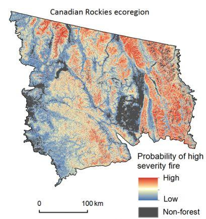
The Next Generation Fire Severity Mapping is a tool designed to depict the probability of high-severity fire, if a fire were to occur, for several ecoregions in the contiguous western U.S. Statistical models were used to generate “wall-to-wall” maps for 13 of the 19 ecoregions.

Read the full brief here.

Posted by:
Gloria Edwards
Published on:
May 7, 2020

Categories: Maps, Models, and Apps, Publication, Research Brief/SynthesisTags: Colorado Plateau, fire data, Great Basin, high-severity wildfire, Western U.S.

Footer

Connect With Us

  • Facebook
  • Twitter
  • YouTube

Sign up for our newsletter

Got a Question?
Email us.

This regional Fire Exchange is one of 15 regional fire science exchanges sponsored by the Joint Fire Science Program (JFSP).
View resources from multiple exchanges.