• Skip to primary navigation
  • Skip to main content
Southern Rockies Fire Science Network

Southern Rockies Fire Science Network

JFSP Fire Science Exchange Network

  • Home
  • About
    • About Us
    • Our Partners
  • Subregions
    • Why Subregions?
    • Black Hills
    • Wyoming Sagebrush
    • Uinta Basin
    • Wasatch Plateaus/Mountains
    • Rocky Mountains
    • Canyonlands/Desert Montane
  • Events
    • Event Summaries
  • Resources
    • Pre and Post-Fire Emergency Resources
    • Research & Publications
    • Maps, Models & Apps
    • COVID-19
  • Contact
  • Show Search
Hide Search

Firefighter Safety

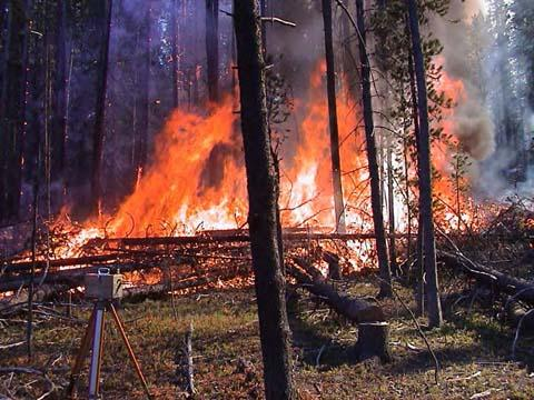
Perhaps one of the most critical decisions made by firefighters during daily fire management operations is the identification of suitable safety zones.

New research is focused on measuring and predicting the cumulative impact of convective and radiant energy transfer on safety zone shape, size and location when the safety zone and/or fires are located on slopes or are burning under the influence of wind. Measurements and newly developed theoretical modeling tools are being used to explore the expected range of slopes, safety zone locations and fire intensities.

Tools/Resources:

Firefighter Safety App

Safety Zone Guidelines

Posted by:
Gloria Edwards
Published on:
April 9, 2020

Categories: Education & Training, Maps, Models, and AppsTags: firefighter protection, firefighters, firefighting, USFS, wildfire, wildfire behavior, wildfire behavior modeling, wildfire management, wildfire safety zone

Footer

Connect With Us

  • Facebook
  • Twitter
  • YouTube

Sign up for our newsletter

Got a Question?
Email us.

This regional Fire Exchange is one of 15 regional fire science exchanges sponsored by the Joint Fire Science Program (JFSP).
View resources from multiple exchanges.