• Skip to primary navigation
  • Skip to main content
Southern Rockies Fire Science Network

Southern Rockies Fire Science Network

JFSP Fire Science Exchange Network

  • Home
  • About
    • About Us
    • Our Partners
  • Subregions
    • Why Subregions?
    • Black Hills
    • Wyoming Sagebrush
    • Uinta Basin
    • Wasatch Plateaus/Mountains
    • Rocky Mountains
    • Canyonlands/Desert Montane
  • Events
    • Event Summaries
  • Resources
    • Pre and Post-Fire Emergency Resources
    • Research & Publications
    • Maps, Models & Apps
    • COVID-19
  • Contact
  • Show Search
Hide Search

Painting a picture across the landscape with ModelMap

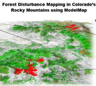
From the Rocky Mountain Research Station:

Scientists and statisticians working for the Rocky Mountain Research Station have created a software package that simplifies and automates many of the processes needed for converting models into maps. This software package, called ModelMap, has helped a variety of specialists and land managers to quickly convert data into easily understood graphical images.

Read the brief here.

Read the original report here.

Posted by:
Gloria Edwards
Published on:
April 8, 2020

Categories: Maps, Models, and Apps, Research Brief/Synthesis, Technical ReportTags: data collection, data sharing, data-driven decisions, forest ecology, Forest Management, forests, landscape restoration and resilience, mapping, Model/Tool/Technology, Rocky Mountain Research Station, vegetation mapping

Footer

Connect With Us

  • Facebook
  • Twitter
  • YouTube

Sign up for our newsletter

Got a Question?
Email us.

This regional Fire Exchange is one of 15 regional fire science exchanges sponsored by the Joint Fire Science Program (JFSP).
View resources from multiple exchanges.